Look at a map of proposed solar parks and battery storage sites in Britain and the pattern is hard to miss. They are not scattered evenly, but can gather within a few miles of one another, while other counties, with just as much open land and just as much sunshine, have almost none.
The reason is that developers are following the wires.
Every solar park and every battery needs a viable connection so that power can be exported to, or drawn from, the network that serves homes, businesses and public services. Substations, high-voltage lines and spare network capacity are not evenly distributed.
That raises another question: why are the wires where they are?
In many parts of Britain, the location of today’s electricity network still reflects decisions made during the coal era.
Much of Britain’s electricity network was built to serve coal-fired power stations, collieries, railways and heavy industry. Many of those industries have gone; the wires, substations and transmission routes built for them have not. Some of the high-voltage infrastructure established during the twentieth century remains part of the electricity system today. New generation can therefore be influenced by routes and connection points established several generations ago.
The grid has its own history
A modern substation can look like a standalone piece of equipment in a field. More often it is one surviving component of a network built up over several generations. Some substations were constructed to receive electricity from large coal-fired power stations and pass it on, through high-voltage lines, to cities and factories. Others grew up around collieries, ports, steelworks and manufacturing sites that needed large amounts of power and were themselves served by railways, roads, rivers and docks.
Not every substation does the same job. Some are transmission assets designed to move large volumes of electricity across the country. Others form part of local distribution networks that deliver electricity to homes and businesses. A substation can therefore sit close to a proposed project without necessarily providing the type or capacity of connection that project needs.
When a pit or a power station closed, the network around it did not close with it. Substations stayed in use, transmission lines kept carrying electricity, and grid routes were reinforced, adapted or taken up by different forms of generation. The result is that the location of a solar project today can be shaped by engineering decisions taken eighty years ago.
Current government policy recognises how important this is. The National Policy Statement for Renewable Energy Infrastructure, EN-3, which came into force on 6 January 2026, states that network capacity, connection voltage and the distance between a solar park and the existing network can have a significant effect on whether a project is technically and commercially feasible.
Why were the original power stations built where they were?
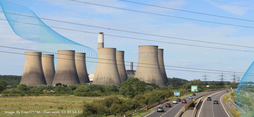
Britain’s coal-fired power stations were not sited at random either, their locations reflected the technology, transport system and economy of the time. A large station needed fuel, cooling water, enough land for a major industrial complex, and a connection capable of moving electricity to where demand was. That made positions near coalfields, rivers and railways decisive.
National Grid’s history of the supergrid explains that the electricity industry built large power stations close to coalfields and water because it was cheaper to transmit electricity over long distances than to transport all the coal to distant cities.
Much of the coal came from the East Midlands, Yorkshire and the North East; much of the demand sat in London, the southern counties, Manchester and Merseyside. High-voltage transmission made it possible to join the two. The consequence was an electricity network clustered around a handful of regions, and the substations, overhead lines and transmission corridors of those regions still shape the energy system today.
Staythorpe and the Trent Valley
The Trent Valley shows how directly historic power infrastructure continues to steer modern energy development. Before large-scale generation arrived, the land around Staythorpe, where one of Elements Green’s BESS is currently being constructed, was rural and agricultural.
The Nottinghamshire Historic Environment Record identifies evidence of former field boundaries around Staythorpe. These features provide a record of the area’s agricultural past and the landscape that existed before major energy infrastructure was constructed.
That landscape changed during the twentieth century.
‘Staythorpe A’ power station was commissioned in 1950, the first of a series of large stations built along the River Trent and fuelled by East Midlands coal. The site offered everything such a station needed: coalfields close by, water from the Trent, railways to move coal, plant and construction materials, and enough open land for a major industrial complex.
From there the electricity could travel. Britain’s first 275kV supergrid circuit was energised at Staythorpe on 15 July 1953, and new high-voltage routes carried power from the Trent Valley towards London and beyond. So much generation gathered along the river that the area became known as ‘Megawatt Valley’.
Staythorpe A was followed by Staythorpe B. Both coal-fired stations have since closed and a gas-fired station was later developed on the site, but the substation and transmission network around it has continued to work.
The University of Nottingham’s Manuscripts and Special Collections holds archive material relating to Staythorpe Power Station and the development of electricity infrastructure around the site. Its catalogue includes records dating from the 1940s, 1950s and 1960s covering the power station, transmission infrastructure and associated works.
The proposed Great North Road Solar and Biodiversity Park would connect to the existing National Grid substation at Staythorpe.
The availability of that connection is a central reason the project is proposed where it is. Land use, agricultural quality, environmental conditions and technical constraints have shaped the site selection alongside it.
The project is therefore potentially part of the Trent Valley’s much longer history of generating and transmitting electricity, using established energy infrastructure for a different form of generation.
How power infrastructure changed the landscape
The arrival of large-scale electricity generation represented a significant change to many rural and industrial landscapes. Pylons, substations, generating halls and associated infrastructure that may now feel established were new features when they were constructed.
Historic England describes twentieth-century coal and oil-fired power stations as some of the largest and most recognisable industrial complexes built in Britain. It records that they had a major visual, environmental and cultural impact on the surrounding landscape. Staythorpe was part of this wider transformation.
A different era of electricity generation
The electricity infrastructure developed during the coal era was built within a very different environmental and regulatory context from today. Coal combustion contributed substantially to historic air pollution in Britain, alongside domestic fires and industrial emissions.
In December 1952 a temperature inversion settled over London and held smoke and sulphur dioxide from domestic fires, factories and coal-fired power stations at street level for five days. The National Archives records that more than 4,000 people died in the immediate aftermath (The National Archives, The Great Smog of 1952).
The Clean Air Acts of 1956 and 1968 progressively tightened controls on smoke and emissions. The way Britain generated electricity also continued to change, including the location and design of large power stations and the way their emissions were managed.
The important point for today’s electricity system is that much of the network developed during that period remained. Substations, transmission routes and connection points continued to evolve as the sources of electricity changed.
Why several modern projects can appear in the same area
A strong connection point attracts more than one developer, but that does not mean every project near a substation will be able to connect. Infrastructure on the ground is not the same as capacity on the network, and each project needs a connection agreement, technical assessment and evidence that it is far enough advanced to proceed.
The connections system is also being reformed. The National Energy System Operator’s connections reform programme is designed to prioritise projects that meet readiness and strategic alignment criteria. Projects must demonstrate that they are sufficiently advanced and aligned with the future needs of the electricity system.
Where a viable connection does exist, developers look for land within a practical distance of it. Longer cable routes mean more land agreements, more survey work and more construction, and they may have to cross roads, watercourses, habitats, archaeological sites and other people’s property. That is why several proposals can gather around the same substation or the same transmission route.
Batteries cluster
Grid access can be an even stronger locational factor for battery energy storage projects.
A solar park needs open, reasonably level, reasonably sunny land. Battery storage does not depend on sunshine, aspect or agricultural land quality in the same way. A viable grid connection can therefore play a particularly important role in determining where a BESS project is proposed.
Solar generation and battery storage can also be developed together. Where technologies share or make use of infrastructure around the same connection point, communities may see several different energy proposals concentrated within a relatively small area.
The land still needs to be suitable
A grid connection is necessary, but it does not make a site suitable. Every candidate area has to be tested against a long list of constraints:
- Topography and slope
- Agricultural land quality
- Flood risk and drainage
- Ecology and biodiversity
- Landscape character and views
- Homes and residential amenity
- Heritage and archaeology
- Public rights of way
- Road access and construction routes
- Existing land use
National policy requires these factors to be weighed during site selection, design and assessment. Some areas are removed from a scheme altogether because their impacts cannot be managed; others are kept but need buffers, setbacks, planting, different access arrangements or a rerouted cable.
For solar projects, an application or project boundary can include much more than the areas ultimately occupied by panels. Hedgerows, watercourses, roads, substations, biodiversity areas, access tracks, buffers and underground cable corridors can all form part of the wider site.
Understanding the full picture
Solar and battery projects are not distributed evenly because Britain’s electricity network is not distributed evenly. That network still reflects where the coalfields, rivers, ports, railways, power stations and industrial communities were.
A cluster of projects therefore does not necessarily mean that an area has been selected simply because it has more open land than somewhere else. It can reflect the geography of the electricity network and the limited number of places where new generation and storage can secure viable connections.
Grid availability is only one part of site selection. Each individual project still needs to demonstrate through the relevant planning process that its location, design and impacts are acceptable. A grid connection can explain why developers look in a particular area; it does not, by itself, establish that every proposed site is suitable.
Image: By Crep171166 – Own work, CC BY-SA 4.0, https://commons.wikimedia.org/w/index.php?curid=92180714